
GPS tracking with sports watches and smartphones – technology, accuracy and tips
 By Philipp Avenell ·
2 min read
By Philipp Avenell ·
2 min read
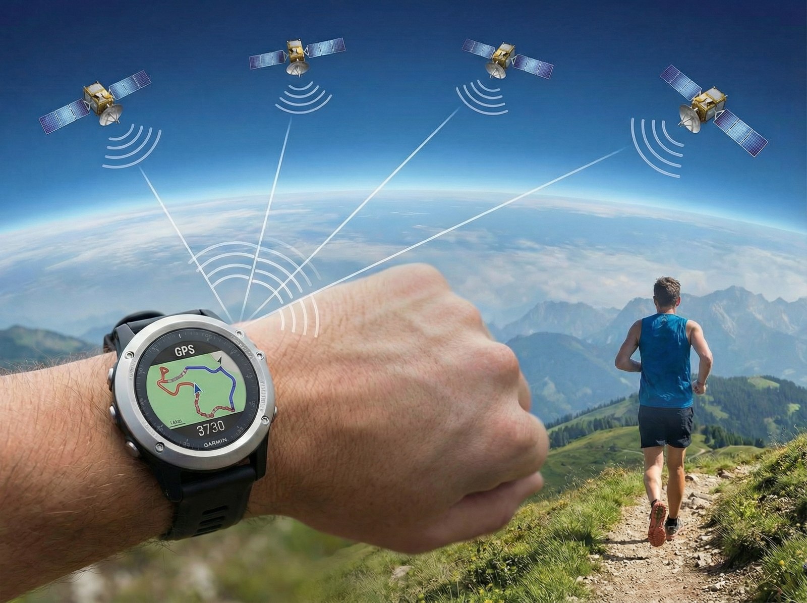
GPS tracking has become an integral part of everyday life for tech enthusiasts and active sportspeople. Whether jogging, cycling or hiking – modern sports watches and smartphones record the route you have covered and deliver pace, distance and elevation gain. But how does position determination actually work in detail?
Here we explain, as clearly as possible, what lies behind GPS, which different satellite systems exist and how current devices deliver ever more precise data through dual-band GNSS and sensor fusion. We also look at the differences between smartphone and sports watch when it comes to tracking, at typical error sources (keyword: GPS drift), and give tips on how to interpret GPS data correctly. The aim is to show both tech-curious and sporty, active readers what good GPS tracking comes down to.
What is GPS and what is GNSS?
The term GPS is often used colloquially for any kind of satellite navigation, but strictly speaking it refers to the Global Positioning System developed by the US military. GPS is therefore only one of several global navigation satellite systems – grouped under the umbrella term GNSS (Global Navigation Satellite System). Alongside GPS (USA), there are also Galileo (Europe), GLONASS (Russia) and BeiDou (China) as further GNSS constellations. Each of these systems operates a fleet of satellites that orbit the Earth and transmit navigation signals.
Worldwide, modern receivers frequently pick up signals from several GNSS at the same time to determine their position. A smartphone, for example, typically uses GPS and Galileo in parallel (and often GLONASS/BeiDou too) – this is known as multi-GNSS. This combination increases the number of visible satellites in the sky, which leads to better coverage and accuracy. GNSS is therefore the umbrella term, GPS an individual system beneath it. To clarify:
GPS (USA): The oldest GNSS, in operation since 1978, today around 30 active satellites. Available worldwide, standard civilian accuracy of around 5 m in normal operation; with modern dual-band receivers, <1 m is possible.
Galileo (EU): The European system (fully operational since 2016) with ~30 satellites. Offers dual-frequency signals for higher precision (in part <1 m) from the outset and is optimised specifically for civilian applications.
GLONASS (Russia): The Russian system (24+ satellites). Somewhat lower individual accuracy than GPS, but robust especially at northern latitudes (thanks to its orbital inclination) and, combined with GPS, a valuable addition in difficult areas.
BeiDou (China): The youngest system (global roll-out ~2020, more than 45 satellites). Leading in Asia-Pacific and increasingly integrated worldwide. Alongside positioning it also offers special functions (message transmission), but is above all interesting in combination with other GNSS.
GPS vs. GNSS: So while people colloquially talk about GPS, today's sports watches/smartphones mostly use multi-constellation GNSS. That means they receive signals in parallel from GPS and Galileo, often also GLONASS and BeiDou, in order to achieve the best possible position fix. As a result, you still see coordinates (latitude/longitude) on the device – but the data basis is broader and more resilient than in the days when only GPS was available.
How does GPS work technically?
The technical workings of GPS positioning rest on precise time measurement and geometry. In principle, the satellites continuously transmit radio signals with coded timestamps and their orbital information. A GPS receiver (e.g. in the watch) picks up these signals and measures the travel time: from the travel time (multiplied by the speed of light c) it calculates the distance (pseudorange) to the respective satellite. Since the signal travels at the speed of light (~300,000 km/s), the time measurement requires atomic-clock-level synchronisation. GPS satellites therefore carry atomic clocks on board, and the receiver aligns its internal time with the satellite signals.
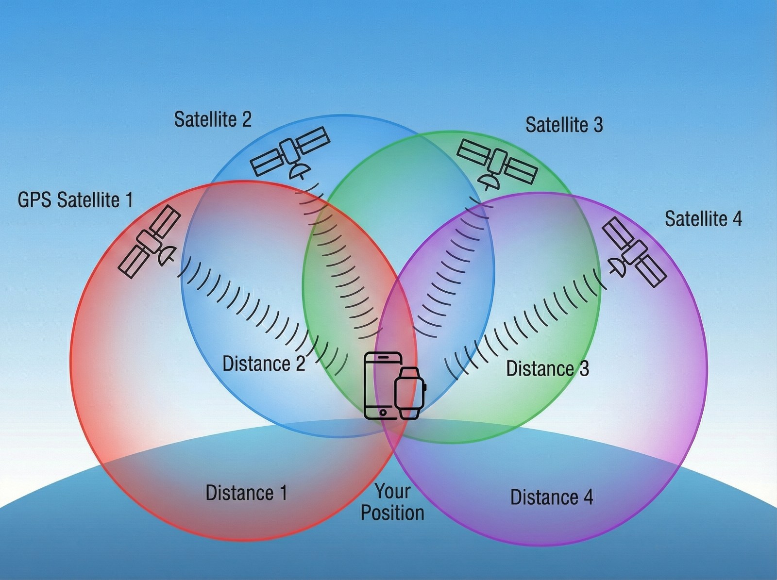
Trilateration: If you know the distance to one satellite, you are located somewhere on the surface of an imaginary sphere around that satellite (radius = distance). With three satellites, two possible positions can in theory be determined (the intersection of three spherical surfaces) – one of which can be discarded, since it usually lies far outside the Earth's atmosphere. However, the receiver must also factor in its own clock error. In practice you therefore need at least four satellites to solve unambiguously for the 3D position (latitude, longitude, altitude) and the time correction. Three satellites deliver the horizontal position (2D) plus synchronisation; a fourth adds altitude (3D fix). Modern receivers often use signals from far more than four satellites simultaneously (frequently 8-12 or more at once) by combining the additional measurements statistically via mathematical adjustment methods (least squares, Kalman filters). This increases accuracy, because measurement errors average out and the geometry of the satellites is better taken into account.
Coordinate system: The device typically outputs the calculated position as geographic latitude and longitude, based on an Earth coordinate system. The common reference system for GPS is WGS84 (World Geodetic System 1984) – a global coordinate system referenced to an Earth ellipsoid. All GPS satellites transmit their orbital parameters and position data in this reference system, so receivers worldwide can deliver consistent coordinates in degrees. Example: a typical GPS track displays points as WGS84 coordinates, which are then projected onto maps (e.g. in the sports watch app or Google Maps).
Single-band vs. dual-band GPS/GNSS
GPS was originally operated with a single frequency for civilian users (L1). Single-band GNSS receivers accordingly use only one frequency band per satellite system – typically the L1/E1 band (~1.575 GHz), on which GPS and Galileo transmit their main signals for civilian users. Dual-band GNSS, by contrast, can evaluate two frequencies in parallel, usually L1/E1 and L5/E5 (for Galileo, e.g. E5a at ~1.176 GHz). Why does this matter?
Ionospheric correction: On their way to Earth, the signals pass through the ionosphere, which affects their travel time in a frequency-dependent way (refraction and delay). With only one frequency, the receiver can estimate this error only from rough models. With two frequencies from the same satellite, the difference in travel time can be measured directly and the ionospheric influence thus largely computed out. This noticeably increases baseline accuracy, since a major error factor is eliminated. For this reason, professional GNSS devices have long worked with dual- or multi-frequency technology – although it used to cost several thousand euros. Today, dual-band chips are finding their way into consumer devices.
Multipath effects: In urban street canyons or narrow valleys, satellite signals can be reflected by buildings, rock faces or even dense ground surfaces and arrive at the receiver with a delay. The receiver then picks up "ghost signals" alongside the direct signal, which leads to position errors. A dual-band receiver copes better with such situations: modern GPS chips listen to the same satellite signal on two frequencies and thereby gain more information with which to detect and filter out multipath effects. The different frequencies partly penetrate or reflect off surroundings differently – comparing the two helps identify false travel-time measurements. The result: in difficult environments (big cities, forested gorges) the position remains more stable with dual-band and jumps around less, whereas single-band can more often shift the track.
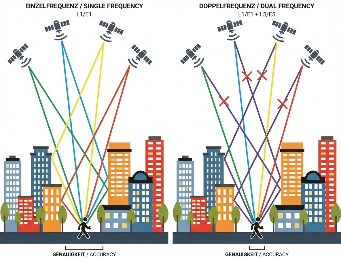
Schematic comparison of single-band vs. dual-band GNSS in the city. On the left, the receiver uses only L1 signals – reflections off buildings (red lines) lead to distorted distance measurements and an imprecise position (red area). On the right, with dual-band (L1 + L5), additional signal information can be evaluated and faulty signals detected (red X). Position accuracy (green area) is significantly higher, because the receiver is better at excluding multipath signals.
The European Galileo system transmits on dual frequency (E1 and E5a) for all users as standard. GPS has also brought its L5 signal into operation (fully rolled out from around 2021). Many newer sports watches and smartphones support this multi-band usage. Example: the first smartphone with dual-band GNSS was the Xiaomi Mi 8 in 2018; dual-band chips are now standard in almost all current high-end GPS devices.
Drawbacks: dual-band GNSS requires more hardware effort and consumes somewhat more power. Some sports watches therefore offer a configurable multi-band mode that can be activated when needed. When it is switched on, however, battery life is often noticeably shorter. Thanks to advancing chip efficiency and features such as Garmin's SatIQ (automatic switching of GNSS modes), this problem is being defused. In everyday use, you can, for example, activate dual-band for a city marathon or a trail run in dense forest and switch it off in easy conditions to save battery.
Sensor fusion: when GPS meets the barometer & co.
GPS alone already delivers a great deal of data – but modern sports watches and smartphones do not rely exclusively on the satellite signals. They combine them with other on-board sensors to obtain a more complete and more accurate picture of the movement. This sensor fusion typically includes:
- Barometer (altimeter): A barometric pressure sensor measures air pressure and can derive changes in altitude from it with great sensitivity. In relative terms this is far more accurate than altitude measurement via GPS, which is prone to noise. High-quality devices therefore use the barometer for second-by-second altitude recording, so that the elevation profile is smooth and realistic. GPS serves in the background for auto-calibration: at regular intervals, the device checks the barometric altitude against the absolute altitude determined via satellite, in order to correct slow drift caused by weather changes. This fusion combines the best of both worlds – the barometer reproduces the relative up/down movements exactly (e.g. it can detect an altitude change of just a few metres), and GPS ensures that the absolute altitude value remains correct over the longer term and is not distorted by air-pressure fluctuations. The result: very accurate cumulative elevation gain and realistic elevation profiles, which is especially important for mountain athletes.
- 3D accelerometer / gyroscope: Practically all smartphones and sports watches contain accelerometers (often 3-axis, including a gyroscope). They register the device's movements, rotations and vibrations. The tracking system can use this data, for example, to count steps, determine cadence or detect changes of direction – independently of GPS. A gyroscope detects rotational movements; the watch thereby "feels" when you turn a corner or change orientation, even if the GPS signal briefly falters. Some manufacturers exploit this deliberately: newer running watches, for instance, have special track-mode algorithms that, thanks to the motion sensor, know when you are running through a bend on the athletics track, in order to correct the GPS there. Even during a brief GPS outage (tunnel, dense city centre), the system can bridge the gap using inertial measurement. A well-known example is Suunto's FusedTrack technology: with a reduced GPS interval (to save battery), the movements in between are reconstructed using the accelerometer so that the track still remains fairly accurate.
- Compass (magnetometer): An electronic compass, which uses the Earth's magnetic field, is also frequently on board. This sensor helps above all with map navigation – it shows the compass direction you are currently facing or moving in. It is not needed for the actual position calculation, but in conjunction with GPS it allows, for example, a map display on the watch to align itself correctly with your direction of travel even when you are standing still (GPS can only derive direction from movement).
This sensor fusion makes tracking data more stable and more meaningful. Take altitude measurement as an example: GPS on its own would often produce tens of metres of altitude noise (a GPS receiver standing still will happily "wander" by ±15 m in its altitude reading). With barometer support, by contrast, the elevation profile looks smooth and small hills are captured realistically. Thanks to its sensors, the watch also notices when you keep running through a tunnel, for instance (the accelerometer counts steps, the gyro holds the direction), and can thus continue the position more plausibly at the tunnel exit instead of producing an outlier. All these aids ensure that sports watches in particular are often more reliable in terms of track quality than the most basic GPS loggers. High-end models (Garmin Fenix, Coros Vertix, Apple Watch Ultra etc.) use automatic calibration and sensor fusion without the user having to intervene – the device, for example, constantly readjusts the barometric altitude and reconciles GPS and motion-sensor data with each other.
GPS tracking: sports watch vs. smartphone – where do the differences lie?
Many people simply use the smartphone in their pocket to record their activities, while others swear by dedicated GPS sports watches or bike computers. So how do smartphones and dedicated sports watches differ in terms of GPS tracking quality? Here are the key points:
- Antenna and casing: Dedicated GPS devices (sports watches, trackers) often have larger, higher-quality antennas positioned specifically for optimal satellite reception (e.g. in the watch bezel or at the top of the device). For reasons of space, smartphones only have small general-purpose antennas and are, moreover, frequently carried in a pocket or held in the hand, which can attenuate the signal. A watch on the wrist with a view of the sky tends to have the edge in reception here.
- GNSS chipset: Sports watches mostly use specialised GNSS chips optimised for accuracy (and power-efficient continuous operation). Smartphones tend to use combined chipsets in their SoCs which, while also very capable, often put energy efficiency before maximum precision. In addition, current premium watches frequently support multi-band GNSS, which is not (yet) standard in all smartphone models.
- Software algorithms: The firmware of sports watches is designed to filter and smooth GPS data for sporting purposes. Manufacturers invest heavily in optimisation algorithms, for example to remove outliers and compute distances cleanly. Dedicated GPS devices sometimes use very sophisticated filters and Kalman filtering techniques. Smartphones often rely on the base system (Android/iOS location services), which is kept fairly generic. There, position updates may arrive less frequently for energy-saving reasons, or heavy data filtering may be applied, which can reduce accuracy. In short: a sports watch "knows" that on a run you are probably following the path, and can smooth out small GPS jumps, while a simple tracking app may show more noise.
- Data sources (A-GPS & co.): Smartphones use additional positioning data such as Wi-Fi networks, Bluetooth beacons or mobile network cells to improve the location fix or obtain it faster. So-called Assisted GPS (A-GPS) delivers an initial position and time via the internet, which speeds up the satellite fix. During tracking itself, a phone app can, for example, incorporate Wi-Fi signals in cities. Sports watches without a mobile connection, on the other hand, rely purely on GNSS satellite data (apart from the initial A-GPS download via the paired smartphone). As a result, phones sometimes have an advantage in city centres with a fast first fix and, when stationary, can estimate the position from networks. During continuous recording (outdoors with good reception), however, these auxiliary data play a lesser role.
- Interference and reception: In difficult environments (see the next section on error sources), the differences can become visible. A watch with a powerful antenna up on the wrist often still receives sufficient satellite signals even on twisting trails or in dense forests, while a smartphone in a back pocket is more heavily shielded and may "lose" the signal more often. In urban street canyons, however, both device types are challenged – here, whoever has multi-GNSS and dual-band on board benefits. Some tests show that more specialised outdoor watches are somewhat more robust against interference. On the other hand, thanks to the auxiliary data mentioned, smartphones can sometimes still display a position despite weak GPS reception (albeit an imprecise one). Overall: open sky = both good; marginal reception = a slight edge for high-quality sports devices, since they were developed for exactly such scenarios.
- Sampling rate and recording interval: Sports watches log a GPS point every second by default (or at least offer the option to do so). This produces a dense track recording that closely traces the actual route. Smartphones and fitness apps, by contrast, often use adaptive sampling rates to save battery – e.g. a position every 4–5 seconds or depending on the distance/speed covered. Less frequent updates can lead to a "more angular" track and slight distance deviations, since a straight line is simply assumed between two points. Many sports watches do also offer an economy mode, but normally 1-second logging is the standard. In short: for steady movement the phone may suffice, but with interval training, lots of corners or stop-and-go, a sports watch often captures the details more completely.
Smartphones today are astonishingly precise and, thanks to multi-GNSS, entirely sufficient in typical situations (jogging in the park, cycle paths). The differences show at the margins: anyone who moves through difficult terrain, or wants their performance data as exact as possible, benefits from the specialised hardware components, algorithms and sensors of a good sports watch. It is built to log GPS continuously, even for 5 hours at a stretch, and deliver stable results while doing so – whereas a smartphone is primarily a communication device that does GPS on the side and makes greater compromises (energy saving, everyday use). Last but not least, battery life plays a role: a sports GPS can usually track for 10+ hours, where a phone battery may give up sooner. Then again, you almost always have your smartphone with you. So it comes down to the use case – for important competitions or mountain tours, though, ambitious users mostly rely on dedicated devices because they value their reliability.
Influencing factors: typical error sources and accuracy
No GPS track is perfect – a wide variety of environmental and signal conditions can impair measurement accuracy. Here are the most important influencing factors and error sources, which explain why a track can sometimes become inaccurate:
- View of the sky: GPS works best with a clear view of the sky (at least 15° of elevation above the horizon on all sides). Tall buildings (street canyons) block or reflect signals – in city centres the position therefore frequently "jumps" or can be offset by tens of metres. Natural gorges and valleys have a similar effect: between mountain flanks or in narrow valleys, often only a small patch of sky is visible, so fewer satellites are available and the signal is reflected off rock faces. The result: poorer accuracy or brief signal loss.
- Dense forest and leaf canopy: Trees attenuate GPS signals considerably. In forests – especially with wet foliage or coniferous woodland – the signal can be weakened to the point that positioning accuracy drops or the device only receives points irregularly. Dense treetops also cause multipath effects, as the signals are refracted by branches. Good devices partly detect this and filter the noise, but a deviation of a few metres is normal in the forest.
- Indoors, tunnels, underpasses: GPS barely penetrates under a roof. Inside buildings you usually have no reception – the smartphone may then fall back on Wi-Fi/mobile network positioning, which is useless for tracking, however. In tunnels or underground stations, GPS fails completely. Sports watches ideally pause the distance measurement or extrapolate via sensors (step counter) in the tunnel. Nevertheless, GPS tracks through tunnels often end up with straight lines (between the last and the next GPS point), which of course do not correspond to the real route.
- Shielding by the body or objects: Interestingly, even the human body can shield GPS signals, since it consists of ~70% water (water absorbs microwaves). If, for example, you carry a phone in your hand and hold it close to your body, or run in a dense group of people (e.g. a marathon start pen), reception can deteriorate. Garmin explicitly lists "using GPS in a dense group of people" as an accuracy problem. This explains why the track sometimes fluctuates at the start of a race – hundreds of runners around you are blocking part of the view of the satellites.
- Multipath reflections: As already mentioned, reflections off hard surfaces (buildings, rocks, bodies of water, large vehicles) lead to multipath errors. The receiver perceives a signal late and from the wrong direction. Typical symptom: the drawn route suddenly "jumps" to a wrong location or shows a spike away from the actual path until the signal recovers. In cities, for example, you see tracks that hop alternately from one side of the street to the other – caused by reflections off glass facades. Dual-band devices and multi-GNSS help here, but the problem is never entirely eliminated.
- Satellite geometry (GDOP): It is not only how many satellites there are but where they stand that influences the quality of a position solution. Ideally, the available satellites are nicely distributed across the sky (e.g. one far to the north, one to the south, one to the east, one high in the west) – then the geometric spread is wide and the so-called DOP value (dilution of precision) is low. If the satellites happen to be unfavourably arranged (e.g. all on one side of the sky), accuracy deteriorates significantly even when there is reception. This phenomenon explains, for example, why better GPS data is possible at a given place at some times than at others (the satellites do, after all, travel along their orbits). Professional applications calculate the GDOP and, if necessary, wait for a better "window". In sports devices this is less visible, since they always use many satellites simultaneously (multi-GNSS reduces the risk of poor geometry here).
- Atmospheric effects: The ionosphere and troposphere can slow down or deflect GPS signals (refraction). The ionospheric delay depends on the time of day and solar activity and can lead to errors in the metre range. Simple receivers correct roughly via a model, whereas dual-frequency receivers measure the delay directly (see dual-band) and greatly reduce this error. Weather conditions (heavy rain, dense clouds), by contrast, have little effect on GPS in the L-band – the signal passes through clouds almost unhindered, unlike satellite television, for example, which fails in heavy rain.
- GPS drift and noise: Even under ideal conditions, a GPS position is never completely exact but always fluctuates slightly around the true value. This baseline noise is in the range of 3–5 m for good devices. Manufacturers such as Garmin state ~3 m accuracy for sports watches in 95% of measurements. The small deviations lead to the phenomenon of GPS drift: if you stand still, the recorded point slowly "wanders" about. To the user, this can look as if the track is jumping back and forth for no reason. In addition, the device may add up these minimal position changes into distance – so you continue to "cover" metres while standing still. Garmin states that with normal GPS drift, up to around 180 m of distance can be falsely counted per minute of standstill if you do not pause the recording! This numerical example illustrates the influence of the noise. In practice, many devices mitigate this by stopping the distance count below a certain speed or offering an auto-pause (see interpretation). Still: a few metres of inaccuracy per kilometre is completely normal.
So how accurate is GPS tracking? Under optimal conditions (clear view, multi-GNSS) you can assume ~3 m horizontal accuracy. In dense cities or forests, the deviations can grow to 10 m and more. Altitude readings via GPS tend to be less accurate (often ±10 m or more) owing to the less favourable geometry – here a calibrated altimeter improves matters considerably. Overall, experience shows that the distance measurement of running watches lies in the range of 1–3% error. That means an officially measured 10 km run is frequently recorded as ~10.1 km (slightly "too long"). This slight over-distance arises, among other things, from countless small zigzag deviations (systematic overestimation). Important: these are typical deviations, not guarantees – depending on the circumstances it can also be better (or worse). With the following tips, however, you can get the best possible accuracy out of your device.
Why are dual-band and multi-GNSS important for athletes?
Anyone who does sport ambitiously – be it trail running in the mountains, cycling in the forest or a city marathon – will benefit from the modern GNSS features multi-GNSS (several satellite systems) and dual-band (several frequencies). Here are the reasons why these technologies are so relevant precisely in a sporting context:
- Better reception in difficult environments: When doing sport, you are not always out in the open. Runners and bikers in particular often pass through varied terrain – a park avenue today, a street canyon tomorrow, a mountain path the day after. Multi-GNSS ensures that as many satellites as possible are available in the sky at all times. If GPS alone falls into a shadowed area, Galileo or BeiDou may still deliver signals from another angle. This increases the availability of the signal. Dual-band, in turn, keeps the position solution stable even when reflections occur or the ionosphere exerts a strong influence, for example in the mountains. The position drifts less and remains more accurate where single-band receivers might lose accuracy. For athletes this means: the track is recorded continuously, even in otherwise problematic passages (dense forest, city centre), and large outliers are reduced.
- More accurate pace and distance measurement: During intervals or competitions in particular, athletes pay attention to precise pace figures. If the GPS is inaccurate, however, the current pace can jump around or the distance can end up wrong. Dual-band GPS offers considerably more consistency here. Without dual-band there is a higher probability that corners get cut and the distance is thereby shortened – which would be fatal on a trail run with lots of switchbacks, for example, if the watch measures 1 km less at the end. Multi-band GNSS delivers clean route coverage, so pace figures and split times are correct. Sports watches with dual-band, for instance, also show smoother pace values in the city centre, whereas older models would happily jump from 4:30 to 6:00 min/km just because the signal briefly suffered. For ambitious runners this is a great advantage, as training progress becomes more accurately measurable.
- Fewer "GPS dropouts" in recordings: Everyone knows it – analysing your run afterwards, you suddenly find a spike where you supposedly ran through the lake or cut 100 m off the course. Multi-GNSS and dual-frequency significantly reduce such gross blunders. Of course, errors can still happen even with them, but robustness increases. Precisely in longer endurance events (ultra runs, marathons), small inaccuracies add up. With high-precision GNSS you end up with a more exact total distance. That can decide victory or defeat when navigation races are involved, for example (think orienteering – every metre counts here).
- Future-proofing: The GNSS world keeps evolving. More Galileo satellites are coming, GPS is activating new signals, and services such as the European correction system EGNOS are improving accuracy. A device that is multi-GNSS capable can make use of these improvements. Many current watches, for example, allow new satellite systems to be added via firmware. For athletes who use their device for several years, that is a plus – you are ready for future gains in accuracy.
In sum: multi-GNSS + dual-band = maximum position quality, which increases track fidelity and metric accuracy especially in sport. So if you train a lot in challenging environments (big cities, trails), or simply want the most accurate track, you should consider a device with these capabilities. In the next section, we look at how the track recording itself can be influenced (keywords: recording interval and smoothing).
Track recording: smart recording vs. 1-second interval & smoothing
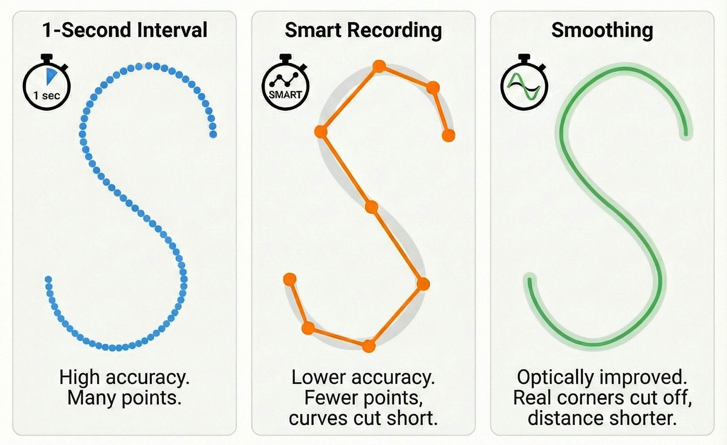
Beyond the pure GNSS technology, the way the data is recorded also plays a role in the accuracy of a track. Two important aspects here are the recording interval (regularly every second or "smart") and subsequent smoothing/filtering of the track.
- Smart recording vs. 1-second intervals: Some sports watches (and older GPS devices) offer a mode in which not every one-second point is stored, but only "important" points. Historically, the aim was to save storage space and extend battery life. In smart recording mode, data points are logged at irregular intervals – namely only when certain criteria are met. For example, the watch stores a new point when it detects a noticeable change in the direction of movement, or when speed, heart rate or altitude change significantly. If you keep going straight ahead at a constant pace for a while, correspondingly fewer points may be set. Modern devices have plenty of storage, but smart recording is sometimes still present as an option (or default) for compatibility reasons. The drawback: by omitting points, fine details can be lost. In particular, start/stop points or sharp corners may be "rounded off", because no point happened to be stored exactly there. This leads to small distance errors – a smart recording track can, for instance, cut a 90° corner into a slight diagonal. For everyday runners this may hardly be noticeable, but in competition segments it can affect timing. Experts therefore often recommend setting the recording to 1 second, provided battery life and storage allow it. On new watches this is usually the default anyway, whereas older Garmin devices sometimes shipped from the factory in smart mode. Incidentally: thanks to efficient chips, 1-second logging now barely consumes noticeably more battery – so the historical advantage of smart recording is almost obsolete.
- Smoothing algorithms: An aspect that is less obvious: how the recorded GPS points are joined into a route and possibly smoothed. Viewed raw, successive GPS fixes could produce a wild zigzag, because the signal scatters slightly around the true value. Many sports watches and apps therefore use a smoothing algorithm to improve the track visually and metrically. In concrete terms, the software tries to reconstruct the probable actual movement from the sequence of points. A simple method: average out small outliers so that a reasonably smooth path results. The problem: if you smooth too heavily, you can "sleep through" genuine changes of direction. The watch might assume you are continuing straight ahead although you have actually turned off – until the extent of the deviation becomes large enough and the software "notices" that there was a corner after all. The corner may then be rendered cut off in the track. One example is 400 m athletics tracks: athletes run tight bends here. Many GPS watches tend to record distances that are too short on the track (e.g. 390 m instead of 400 m per lap), because the smoothing algorithm does not fully register the tight changes of direction and cuts the corners of the lap. Conversely, however, smoothing prevents the track from jittering back and forth on a straight like a "drunken zigzag course". So it is a balancing act. Exactly how the filters work is usually a trade secret of the manufacturers, but it can be observed that Garmin smooths moderately (routes sometimes measure minimally shorter), Polar smoothed more heavily in older models (which led to noticeable under-distance), and Apple even uses AI models on the Watch to optimise the track afterwards. Important to know: smoothing affects the track display and the distance measurement. So if your recorded route runs very "cleanly" along a road, an algorithm may also have lent a hand (such as map-matching onto the road layer, which many navigation apps do). For sports watches, however, the manufacturers try to strike the balance: suppress noise on the one hand, but do not distort real movements on the other.
Example – smart vs. 1 s vs. smoothed: suppose you are cycling at a steady pace on a winding pass road. A watch in 1-second mode sets a point every second – the track will resolve the bends finely. In smart mode, by contrast, the device may only set a point at each major hairpin; in between, the route is interpolated as a straight line – in extreme cases, switchbacks could be "cut". If heavy smoothing is then applied on top, the curve radii could be straightened further. The consequence: the total distance measured is noticeably shorter than the actual one. For precise analysis, you should therefore always use 1-second logging. Smart recording is intended more for occasions when storage is scarce or the route is incidental (practically no longer a scenario today).
Fortunately, many newer devices have abolished smart recording or hide it deep in the menu. If your sports watch offers the option, it is advisable to set it to "every second" – the battery penalty is minimal, the data quality higher.
Interpreting GPS data: jumps, shortcuts and other anomalies
When analysing your recorded GPS tracks (be it on Strava, Garmin Connect or another platform), you occasionally come across unusual track shapes. Here are a few typical phenomena and tips on how to read them:
- Accept slight distance deviations: GPS is never 100% exact. It is normal for an officially measured run (e.g. 5.00 km) to appear on the watch as 5.05 km or 4.95 km. Typically, the deviation is around ±1% of the distance. That does not mean the course is wrong or the device is "bad" – it is simply measurement inaccuracy. At competitions, many organisers allow for this tolerance (most running watches measure slightly long). So: no panic if the marathon watch shows 42.8 km – you did not run "too far"; the GPS just added a little.
- Sudden GPS jumps in the track: Sometimes you see sharp spikes or teleport-like offsets in the route. The cause is usually signal errors such as multipath reception or a brief outage. In a city centre, for example, the GPS can make you jump onto a parallel side street for a few seconds (reflections off buildings). Such outliers can often be recognised by unrealistically high speeds having been calculated for a short time (e.g. a jogging pace of 100 km/h). A single jump can be removed from the route later (many platforms smooth this out automatically). What matters is knowing that such jumps are technical artefacts, not real movements. So if your track goes straight across a rooftop although you were running on the street below, the signal was briefly inadequate. Dense development and tunnels in particular produce such errors. Here it helps, if possible, to wait a few seconds until the signal has stabilised.
- Cut corners and shortcuts: If your recorded path smooths out corners (as if you had run/ridden along the inside of the bend), this is due either to too low a point density or to algorithmic smoothing (see the previous chapter). Particularly with older recordings using a 5-second interval, it happens that switchbacks, for example, are rendered only roughly and angularly – the device simply did not capture the shape with enough points. Heavy smoothing can likewise cut corners. Interpretation: your actual route was somewhat longer than the track. For orientation purposes this does not matter, but for exact pace calculations you have to keep it in mind. Modern watches in 1-second mode, however, hardly cut corners any more – if they do, aggressive filtering could be the reason (some platforms let you display "original data" vs. "smoothed").
- "Snaking line" despite a straight route: Conversely, there are cases where in reality you ran straight ahead, but the track shows small wiggles. This is usually GPS noise – that is, the signal varied minimally, which the track renders as a zigzag. You often see this when walking slowly or in the forest: the track wobbles left/right around the path. These snaking lines can lead to slight over-distance, since the back-and-forth is counted as extra metres. Many algorithms (fortunately) partly smooth this out. But if you have a very jittery track, reception was possibly poor. Tip: in dense forest, hold the watch slightly away from your body if necessary (e.g. attach it to the shoulder strap of your backpack) so that it has a better view. That can reduce the snaking lines.
- GPS drift while stationary: As described above, the GPS position moves slightly even when you are standing still. So if you stop for a longer moment during a recording (a break at the traffic lights, enjoying the view etc.), your track may draw a little loop or a chaotic pattern at the stopping point. Distance may also be falsely added as a result. Tip: during breaks, use your sports watch's auto-pause feature (if available) or stop the recording manually when accuracy is the top priority. That way you prevent 5 minutes of standing still being rewarded with 100 m of "movement". Start again once you set off – modern devices usually reacquire the GPS signal quickly.
- Question elevation data: GPS elevation gain should be interpreted with caution. If you do not have a barometer in your watch, the recorded ascents/descents can be massively wrong – e.g. a flat run suddenly shows +200 m of elevation gain although it hardly went uphill at all. This comes from GPS altitude drift and errors in the altitude calculation. Sports platforms such as Strava sometimes offer elevation-data correction: your GPS track is compared against a terrain model to obtain more realistic elevations. If your watch does have a barometric sensor, however, trust that data instead – it is usually more accurate, as long as the sensor was calibrated. Check whether your device calibrates elevation automatically (often via GPS at the starting point or via known POIs). Interpretation tip: small bumps in the elevation profile can be noise; look more at the total elevation gain. If, for example, you run in flat country and the watch shows +50 m, you can ignore it – that was GPS noise.
- Cross-check with the map: A useful trick for interpretation is to view the track on a satellite or trail map. Many deviations fall into perspective when you see: "Ah, the point is next to the road, but that is because of the street canyon." Smartphone apps in navigation mode often "snap" the marker to the nearest road to hide this from the user. With the recorded track, however, nothing of the sort is corrected – it shows the raw (or only lightly smoothed) GPS data. So if something looks totally implausible, it is usually an error, not a miraculous teleport. If necessary, compare several laps: if there is always a jump at the same spot, it is probably down to a local source of interference (lots of metal roofs? A radio mast?).
In short: know the limits of your GPS data. A track is never perfectly true to scale – it is an approximation. For most purposes (retracing a route, logging training), the precision is amply high. But you should not over-interpret every spike. If something looks odd, there is usually a technical reason behind it. And if you need maximum accuracy, use the tips mentioned: a good view of the sky, time for the signal fix, dual-band on in difficult sections, use the pause function, etc. Then you will get the best possible data.
What makes good GPS tracking hardware?
To conclude, let us summarise what good GPS tracking hardware comes down to – be it for your next sports watch or smartphone:
- Multi-GNSS support: A modern device should be able to access several satellite systems (GPS, Galileo, GLONASS, BeiDou). This noticeably increases satellite coverage and reliability, especially in urban or difficult environments. Multi-GNSS is now standard in almost all current mid-range and premium smartphones and sports watches.
- Dual-band GNSS (multi-band): For the highest accuracy, dual-frequency reception is a big plus. Good sports watches from 2022 onwards offer dual-band GPS, which delivers measurably more precise tracks and mitigates problems such as ionospheric errors and multipath. If very accurate pace and distance matter to you (e.g. competition or trail athletes), you should go for a dual-band-capable watch.
- High-quality antenna and reception design: The best GNSS electronics are of little use if the antenna is poor. Good-quality devices can often be recognised by a well-thought-out antenna design – such as ceramic patch antennas or metallic watch bezels that serve as the antenna. These enable stable reception even in difficult positions. A smartphone in a thick protective case or strapped to your arm can be at a disadvantage here. So look out for user reports on a device's GPS reception quality.
- Barometric altimeter: For anyone who collects elevation gain (runners, cyclists, hikers), an integrated barometer is a must. Good sports watches have a barometric sensor that is automatically fused with GPS. This produces reliable altitude readings and prevents mismeasurements due to GPS altitude drift. In mountainous terrain or on stair runs you will notice the difference immediately.
- Sensor fusion & algorithms: Top models rely on clever software: they filter GPS data, use motion sensors as a supplement and have functions such as automatic pausing and intelligent recalculation. These algorithms contribute a great deal to the final quality. A "good" GPS watch, for example, recognises thanks to its gyro that you are running on the 400 m track and delivers near-lane-accurate distances (Garmin's Track Run feature). So look out for such features if you are after precision.
- Flexible recording interval: Ideally, the device logs data every second or at least offers the option to do so. Some newer models choose dynamically and automatically (e.g. SatIQ). What matters is that you should not have to sacrifice accuracy through patchy logging. Good devices therefore do without rigid smart recording, or only use it when the user wants it (e.g. in the Ultratrac battery mode).
- Battery life and performance: An outstanding GPS tracking device manages the balancing act between accuracy and endurance. Dual-band and multi-GNSS place greater demands on the battery, yet high-end watches such as the Garmin Fenix or Coros Vertix still deliver over 20-30 hours of runtime in full GNSS mode. That is the hallmark of good hardware – it uses energy-efficient chips and large batteries. Especially important for ultras and multi-day tours: in energy-saving mode, the watch should still offer acceptable recording quality (for instance via FusedTrack or similar).
In summary, good GPS tracking hardware therefore offers: reception strength, precision (through multi-GNSS/dual-band), additional sensors (barometer, gyro) for complete information, clever software for data processing and enough battery for your longest sessions. The current generation of sports watches and also high-end smartphones has made enormous progress here. High-quality running watches, for example, now often achieve an accuracy of ~3 m under good conditions – a figure that seemed utopian in the consumer sector only a few years ago. For you as a user, this means you can largely rely on your track recording. Of course, GPS remains a radio system and not millimetre-precise surveying – but with the right device on your wrist, your runs, bike rides and hikes will be tracked reliably and accurately, so you can concentrate fully on your sport. Enjoy your training – and may you always have good GPS reception!